


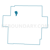
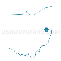
PRECINCT MOHAWK EAST, Carroll County, Ohio
About
Outline

Summary
| Unique Area Identifier | 643289 |
| Name | PRECINCT MOHAWK EAST |
| County | Carroll County |
| State | Ohio |
| Area (square miles) | 2.14 |
| Land Area (square miles) | 1.73 |
| Water Area (square miles) | 0.40 |
| % of Land Area | 81.07 |
| % of Water Area | 18.93 |
| Latitude of the Internal Point | 40.66920720 |
| Longtitude of the Internal Point | -81.17943770 |
Maps

Graphs
Select a template below for downloading or customizing gragh for PRECINCT MOHAWK EAST, Carroll County, Ohio


Neighbors
Neighoring Voting District (by Name) Neighboring Voting District on the Map
- PRECINCT BROWN TWP A, Carroll County, OH
- PRECINCT BROWN TWP B, Carroll County, OH
- PRECINCT HARRISON A, Carroll County, OH
- PRECINCT MALVERN, Carroll County, OH
- PRECINCT MOHAWK WEST, Carroll County, OH